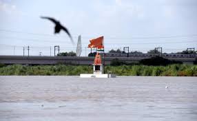
On Wednesday, the Yamuna water level in the city reached a 60-year high. Chief Minister Arvind Kejriwal requested the Centre to take precautions to prevent the level from rising higher. The river’s flow at midnight on Wednesday reached 208.13 metres, the highest level since 1963.
What do we know about Yamuna?
Origin and Length: The Lower Himalayan region’s Yamunotri Glacier, located in Uttarakhand, India, at an elevation of around 4,500 metres (14,800 feet), is the source of the Yamuna River. It is the longest tributary in India, with a total of 1,376 kilometres (855 miles).
Yamuna River Drainage System: The Yamuna River drains a wide area totalling 366,223 square kilometres (141,399 square miles), or 40.2% of the Ganges Basin.
Tributaries: Several tributaries, including the Tonnes, Chambal, Sindh, Betwa, and Ken rivers, join the Yamuna River throughout its length. The Chambal River in particular is the Yamuna’s longest tributary and has a sizable basin of its own.
Confluence: In Allahabad, at a place of worship known as Triveni Sangam, the Yamuna River and the Ganges converge. The Kumbh Mela, an important Hindu celebration, is celebrated every 12 years at this confluence, which is highly significant in Hinduism.
Water dependency: For almost 57 million people, the Yamuna River is a vital supply of water. Given that it provides more than 70% of Delhi’s water supply, it is very significant.
Water Use: The Yamuna River has a yearly flow of roughly 97 billion cubic metres. Nearly 4 billion cubic metres of material are used annually, largely for irrigation. Approximately 96% of the water used is for irrigation.
What’s happening in Delhi now related to Yamuna?
Delhi’s Yamuna River has attained a water level 60 years higher than before, measuring 208.13 meters, the highest level ever seen since 1963.
called for the evacuation of locals who lived along the river due to the floods that the rising water level would cause.
Monastery Market, Yamuna Bazar, Geeta Ghat, and the section of the city from Majnu Ka Tilla to Wazirabad have all experienced flooding.
The Delhi administration has already evacuated nearly 16,500 residents from the flood-affected districts.
Since the massive rains that fell in northern India on July 8–9, the Yamuna River’s water level has been slowly rising.
On Monday, it surpassed the “danger mark” of 205.33 meters, and by Tuesday at 11 p.m., it had climbed to 206.83 meters.
The Delhi government has been evacuating residents of the area and plans to move about 41,000 of them.
From 3.59 lakh cusecs on Tuesday morning to 1.47 lakh cusecs on Wednesday night, the Hathnikund Barrage’s water output has reduced.
The decrease in released water will not immediately affect the water flow in the nation’s capital because it takes between 36 and 72 hours for water from the barrage to reach Delhi.
Did Delhi face a similar situation before?
The Yamuna and monsoon rains worked together over 44 years ago to unleash their fury on Delhi. In September 1978, areas of Delhi, even upscale suburbs, took on a depressing appearance as a result of the flood’s devastation and fatalities. As floodwaters ravaged their houses and possessions, thousands of people were uprooted from their homes and forced to see the devastating loss. Small villages and colonies that have sprouted up around the capital city were submerged in the flood as the Yamuna River’s water level crossed the danger line.
Why is Delhi facing floods?
Rise in Rainfall
Heavy rainfall in Delhi and the adjacent areas: The first element for the situation to resemble a flood is the increasing rainfall in Delhi and the surrounding areas. There is a substantial input of water into the local rivers and drains as a result of persistent, heavy rain.
Urban runoff: Because of the extensive concrete infrastructure present in urban areas, the ground is less permeable. As a result, precipitation cannot effectively percolate into the soil; instead, it flows off into drains and rivers, rapidly raising water levels.
Inadequate drainage infrastructure: Due to high rains, Delhi’s drainage system may not be able to handle the additional water volume. Low-lying locations experience flooding and waterlogging as a result of inadequate drainage capacity.
An Increase in Hathnikund Barrage Discharge:
Hathnikund Barrage: The Yamuna River’s Hathnikund Barrage is situated in Haryana, upstream from Delhi. It is in charge of controlling the water release and regulating the water flow downstream.
Heavy rainfall can result in a higher input of water into the Hathnikund Barrage, which can increase discharge. The catchment basin of the Yamuna River includes areas of Haryana and Uttarakhand. The barrage authorities must release more water downstream as a result of the increased inflow to avoid the structure becoming overwhelmed or failing.
How can we tackle the situation and prevent future floods?
Improve Drainage System: Regularly clearing and desilting the drains will improve the current drainage system. Build new drains, making sure they have enough capacity to handle heavy downpours. To redirect surplus water away from inhabited areas, implement a thorough stormwater management system.
Reservoirs and Water Storage: To collect extra rainwater and keep it from overwhelming the drainage system, construct reservoirs and water storage facilities. During dry spells, water can also be supplied from these reservoirs.
Zoning and Floodplain Mapping: Conduct a thorough investigation to pinpoint flood-prone regions and create floodplain maps. Implement stringent rules to stop construction in certain regions and make sure that existing structures follow guidelines for flood-resistant design.
Wetlands and Green Areas: Delhi needs more wetlands and green areas. They serve as organic insulators, soaking up and storing extra rainwater. Wetlands also aid in the filtration and sanitization of water. Existing wetlands must be protected because they act as flood-control and natural reservoirs.
Early Warning Systems: Create and deploy a reliable early warning system that can forecast rainfall, river levels, and probable flood events. Authorities and citizens can take the required preparations and evacuate vulnerable locations with the aid of prompt alerts.
🕒 Weekend Batch Details
Class: Saturday & Sunday
Time: 10:00 AM – 05:00 PM
Test : Every Sunday
For more details, contact us 9611451616 [email protected]
Evening Batch
🕒Evening Batch Details
Class: Monday to Friday
Time: 05:00 PM – 08:00 PM
Test : Every Sunday
For more details, contact us 9611451616 [email protected]
Regular Batch
🕒 Regular Batch Details
Class: Monday to Friday
Time: 07.00 AM to 10:00 AM and 11.00 AM to 02.00 PM
Class: Saturday & Sunday
Time: 10.00 AM to 05.00 PM
🕒 Morning Batch Details Class: Monday to Friday Time: 07:00 AM – 10:00 AM Test : Every Sunday For more details, contact us 9611451616 [email protected]
Drop Your Details To Get A Free Mentorship / Demo Class Now !