
India, China ramp up infra on the north bank of Pangong Lake
Context :
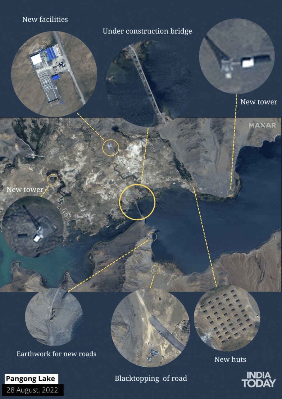
There is a frenzied activity in the area from both sides three years after the bloody fight between Indian and Chinese soldiers in Galwan, which was followed by tanks facing off around the Pangong Tso, a lake crossing eastern Ladakh and western Tibet. China is working quickly to connect the north and south banks of the Pangong Tso with a bridge, while India is constructing a black-topped road on the opposite side of the river on the north bank.
What is the background behind Indo-China Skirmishes in 2020-2021?
- Beginning of Standoff: On May 5, 2020, intense confrontations, face-offs, and skirmishes broke out at several points along the Sino-Indian border, signalling the start of the standoff between China and India.
- Locations: Disputed Pangong Lake in Ladakh, the Tibet Autonomous Region, and the border between Sikkim and the Tibet Autonomous Region were the sites of the battles. There were more battles along the Line of Actual Control (LAC) in eastern Ladakh.
- Objection to Road Constructions: Chinese forces protested Indian road work in the Galwan River valley in late May 2020, which led to an increase in hostilities.
- Casualties and Taken Prisoners: On June 15–16, 2020, soldiers from China and India were killed in melee combat. Both sides of the conflict claimed to have captured soldiers, although official sources refuted these allegations.
- Shifting Line of Actual Control: Indian experts noted that the Line of Actual Control had moved westward at patrol post 17A (PP 17A) after the disengagement at Gogra in August 2021.
- Infrastructure Development: In the disputed border regions, both China and India have been bolstering their infrastructure. India sent out an additional 12,000 personnel to help build infrastructure along the Sino-Indian border. In these disputed areas, China has also massively improved its infrastructure.
Which other areas are under dispute since the Indo-China war?
- Located in the Western Sector of the Sino-Indian border is the region known as Aksai Chin. Although India claims it as a part of the Ladakh Union region, it is now controlled by China. The battle over Aksai Chin has its roots in the competing territorial claims of China and India, which are influenced by historical and geopolitical causes.
- Arunachal Pradesh is a state in northeastern India that borders Tibet, China. South Tibet is how China refers to the entire region, which it claims as its own. The ongoing border conflict between the two nations in the Eastern Sector is directly tied to the Arunachal Pradesh dispute.
- There have been territorial disputes involving the area of Arunachal Pradesh along the Sino-Indian border’s Eastern Sector. The McMahon Line, a border demarcation suggested by the British in the Simla Accord of 1914, is the main point of controversy. The McMahon Line is rejected by China, which asserts that it was signed without their consent and under coercion.
- There are smaller, more localised border conflicts and incursions in places like the Depsang Plains in Ladakh and the Doklam Plateau, which is close to the trijunction between India, China, and Bhutan. There have occasionally been standoffs and tensions between the two nations in certain places.
What are the recent events happening at the border?
- Infrastructure Development in Eastern Ladakh:
-
-
- India is constructing a black-topped road on the north bank of the Pangong Tso, with a completion date of 2025, as part of the development of the infrastructure in eastern Ladakh.
- Reaching Finger 4 on the Indian side is the main goal of the road’s construction.
- Infrastructure development, particularly the construction of modern landing fields and transportation networks, is given considerable priority.
- Additionally, progress is being made on a different route through the Saser La than the Darbuk-Skyok-Daulat Beg Oldie road.
-
- Chinese Infrastructure Development:
-
-
- China is working quickly to connect the north and south banks of the Pangong Tso River with a bridge.
- The auxiliary bridge is already finished.
- On the north bank, there has been extensive construction activity, including road connectivity to Shandong village.
- At Yuli, a 22-kilometre tunnel connecting the crucial G-216 highway in Tibet to the G-0177 motorway is being built.
- East of the Khurnak Fort is a Chinese air defence installation.
-
- Budgetary Allocation and the Border Roads Organisation (BRO):
-
- In recent years, the budgetary allocation for the BRO has significantly increased.
- The BRO’s capital budget for 2023–2024 was 5,000 crore, a 43% increase from the previous year.
- The India-China Border Roads (ICBR) project has received more money.
- Over 1,400 km of key roads are intended to be built as part of the ICBR plan along the Line of Actual Control (LAC).
- The eastern segment of the BRO’s important infrastructure projects, which will improve all-weather communication along the LAC, is almost finished.
What do we know about Pangong Tso Lake?
- Pangong Tso, sometimes referred to as Pangong Lake, is located at a high altitude in the western region of Tibet in China and the eastern region of Ladakh in India.
- Elevation: The lake is one of the highest altitude lakes in the world at a height of 4,225 metres (13,862 ft) above sea level.
- Size: Pangong Tso is one of the largest lakes in this region, measuring over 134 kilometres (83 miles) in length. It has a footprint that is about 700 square kilometres large.
- Sublakes: Five sub-lakes make up Pangong Tso: Pangong Tso, Tso Nyak, Rum Tso (twin lakes), and Nyak Tso. Each of these sub-lakes has distinctive qualities and features of its own.
- International Boundaries: About 50% of Pangong Tso is located in Tibet, China, while about 40% is in the Indian state of Ladakh. 10% of the lake is still up for debate, and it acts as a de facto border between the two nations.
- Geography: Geographically speaking, the Indus River basin and the landlocked basin of Pangong Tso are divided by a small, raised ridge. The Indus River basin and the lake, however, are thought to have been connected in prehistoric times.
- Cultural Significance: A distinctive fusion of Tibetan and Indian traditions can be seen in the area surrounding Pangong Tso. It is a place that offers culturally enriching opportunities for travellers to engage with local customs, cuisine, and festivals.
- Tourism: Pangong Tso has become a very well-liked tourist destination throughout time. Visitors come to the lake to take in its natural beauty, partake in outdoor pursuits like camping and photography, and soak up the peace and calmness of the isolated Himalayan region.
Related Posts


