
Heatwave Days For Eastern India in May
Context:
May, the hottest month in most of India, is expected to be especially hot in eastern India, but Delhi, Punjab, Haryana, Rajasthan, and Gujarat, while still hot, are expected to see increased rain and limited heatwaves, according to the India Meteorological Department (IMD).
Points to Ponder:
- According to the India Meteorological Department (IMD), May is projected to be exceptionally hot in wide portions of eastern India, while Delhi, Punjab, Haryana, Rajasthan, and Gujarat are likely to have considerable rain and fewer heatwaves.
- According to the IMD’s monthly forecast, normal to above-normal rainfall is expected over northwest India, parts of west-central India, and the northern part of peninsular India, while normal to below-normal rainfall is expected over most of northeast India, east-central India, and south peninsular India.
- Heatwaves are likely to be more common in Bihar, Jharkhand, Odisha, Gangetic West Bengal, East Uttar Pradesh, coastal Andhra Pradesh, Chhattisgarh, Madhya Pradesh, Telangana, and coastal Gujarat, where increased humidity levels mixed with heat pose a considerably higher health risk.
- Rainfall in May is predicted to be “normal,” or within a 10% range of what is typical for the month, according to the statement.
- The IMD expects that due to rain, there may not be many days of heatwaves in northwest India.
- The IMD had previously predicted a 4% shortfall for the upcoming monsoon season in April, which is considered “normal,” but at 96% of the Long Period Average (LPA), it is at the low end of what the agency considers “normal.”
- The formation of a ‘El Nino,’ a cyclical phenomena of warming in the Central Pacific connected to less rainfall in west, northwest, and western areas of Central India, is thought to be causing havoc this year.
El Nino
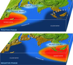
- El Nino is a three to five-year-long abnormal warming of the water in the central and eastern tropical Pacific Ocean that can continue up to 18 months. The El Nino Southern Oscillation (ENSO) phenomena is in a warmer-than-normal phase.
- During an El Nino event, the equatorial Pacific Ocean along the northern coast of South America has sea surface temperatures (SST) that are at least 0.5 degrees Celsius higher than the long-term average.
- In a normal year, there is a high-pressure area in the eastern Pacific Ocean along the Peru Coast due to the existence of the chilly Peru Current (Humboldt Current) along the coast of Peru (South America). As a result, air moves from the eastern Pacific Ocean to the western Pacific Ocean, where pressure is lower.
- Because of the warmer oceans, this air absorbs a lot of moisture as it travels owing to evaporation. This warm wet air climbs to high levels of the atmosphere in the western Pacific Ocean, causing rain in Indonesia, eastern and northern Australia, and other places.
- The rising of warm air eventually causes it to cool in the upper atmosphere. A portion of this air goes into the upper atmosphere and descends over the eastern Pacific Ocean, helping to maintain the higher pressure there, before returning to the western Pacific Ocean. Walker Circulation is the name given to this type of circulation.
- During El Nino years, the high-pressure system in the eastern Pacific Ocean weakens due to excessive warming of water in the central and eastern tropical Pacific Ocean, and the wind moving east (called easterly wind) weakens or even reverses direction. As a result, there is less rain/drought in the western Pacific Ocean (Indonesia, eastern and northern Australia, and New Zealand).
- Tahiti is where the eastern Pacific Ocean’s atmospheric pressure is monitored, while Darwin is where the western Pacific Oceans’ atmospheric pressure is measured. During normal years, Tahiti has high pressure and Darwin has low pressure. During El Nino years, this condition exactly flips, and this process is known as Southern Oscillation.
Related Posts


Cyclone Asani
Posted on
